Fifty nine
Digital Town View Maps
for Illinois


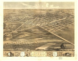
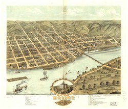
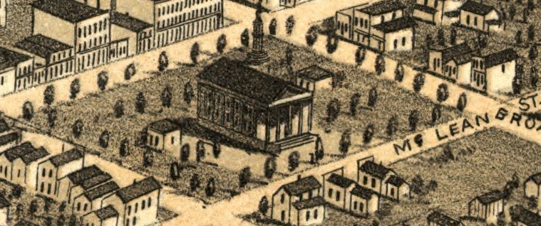
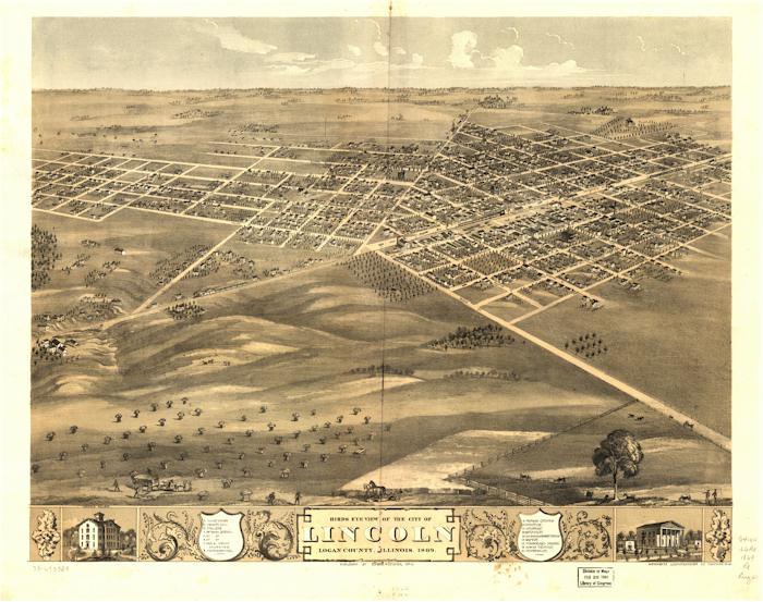
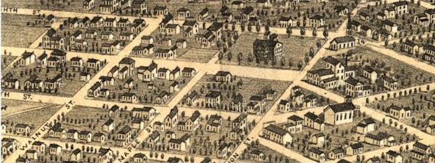
This CD contains 59 high resolution digital images of maps and prints of various Illinois towns from the 19th century. If you are interested in local history or your family genealogy the maps will provide you a glimpse of the time when your great3 grandfather walked the streets.

The maps are drawn in detail giving street name and showing the location of houses, goverenment buildings, churches, schools and lounging animals on the street. When the maps are blown up they do not lose any detail. The map on the top left is of Lincoln Illinois. At the bottom of the page is a part of this map when is was enlarged. As can be noted from the image the resolution is excellent.

Computer Requirements:You need to have one of the following Microsoft OS - Windows 95, 98, NT, 2000, XP and either Netscape 7.x and greater or IE 5.5 and greater browser.

To view the maps you will need to install a plugin for your browser on your computer. The software comes with the CD and installs easily. The software allows the viewer to zoom in on any area of the map. The speed of which it zooms and the clarity of the maps are astounding. The software allows printing of the file and allows file conversion into various graphic file formats. The new file can then be imported into most graphic programs. In a graphic program the file can be manipulated and a small section can be cut and saved as a file. An example of this would be the Logan county courthouse which is shown below. When printing the size of the print can be adjusted to give different sizes of prints.

Book# = IL51
Price=$10.99

Order the CD

Home Page

CD Book Page

  1. Abingdon (Knox Co), 1874
  2. Alton (Madison Co), 1867
  3. Aurora (Kane Co), 1867
  4. Aurora (Kane Co), 1882
  5. Batavia (Kane Co), 1869
  6. Belleville (St. Clair Co), 1867
  7. Bloomington (McLean Co), 1867
  8. Cairo (Alexander), 1867
  9. Cairo (Alexander), 1888
  10. Centralia (Marion Co), 1867
  11. Champaign (Champaign Co), 1869
  12. Chenoa (McLean Co), 1869
  13. Chicago business district, 1898
  14. 3 - Chicago business district, 1916
  15. Chicago (Cook Co), 1857
  16. Chicago (Cook Co), 1860
  17. Chicago (Cook Co), 1868
  18. 2 - Chicago (Cook Co), 1871
  19. Chicago (Cook Co), 1874
  20. 2- Chicago (Cook Co), 1892
  21. 2- Chicago (Cook Co), 1893
  22. Clinton (DeWitt Co), 1869
  23. Danville (Vermillion Co), 1869
  24. Decatur (Macon Co), 1869
  25. Elgin (Kane Co), 1880
  26. El Paso (Woodford Co), 1869
  27. Geneva (Kane Co), 1869
  28. Highland (Madison Co), 1894
  29. Homer (Champaign Co), 1869
  30. Kankakee (Kankakee Co), 1869
  31. Lincoln (Logan Co), 1869
  32. Loda (Iroquois Co), 1869
  33. Manteno (Kankakee Co), 1869
  34. Mattoon (Coles Co), 1884
  35. Moline (Rock Island Co), 1869
  36. Moline (Rock Island Co), 1889
  37. Monmouth (Warren Co), 1869
  38. Mount Sterling (Brown Co), 1869
  39. Mount Vernon (Jefferson Co), 1881
  40. Naperville (DuPage Co), 1869
  41. Paxton (Ford Co), 1869
  42. Peoria (Peoria Co), 1867
  43. Pontiac (Livingston Co), 1869
  44. Princeton (Bureau Co), 1870
  45. Rockford (Winnebago Co), 1880
  46. Rockford (Winnebago Co), 1891
  47. Rock Island (Rock Island Co), 1869
  48. Rock Island (Rock Island Co), 1874
  49. Rock Island (Rock Island Co), 1889
  50. Sandwich (De Kalb Co), 1869
  51. Shelbyville, (Shelby Co), 1869
  52. Springfield, (Sangamon), 1867
  53. Urbana (Champaign Co), 1869
  54. Young America (Warren Co), 1869